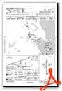
KAPN (Alpena County Regional Airport in Alpena, Michigan United States)
79MI (Pike River Landing in Chassell, Michigan United States) No Parking/Gates!
77G (Marlette Township Airport in Marlette, Michigan United States)
Click "Copy Link" to copy to your clipboard:

Click button to download a .PLN file of these hops.

Airport Codes:
77G-KAPN-79MI-77G
STARTING AIRPORT "Marlette Township Airport / 77G"
============
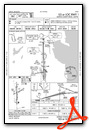
Marlette Township Airport (77G)
| Unicom: | 122.800 Mhz |
| Elevation: | 879 FT |
| Airport Location: | Marlette, Michigan United States (N43° 18' 42.60",W83° 5' 27.31") [Google Maps] |
| Airport Information: | [Skyvector] [Airnav] [FlightAware Arrivals] [FlightAware Departures] [FlightPlanDB Arrivals] [FlightPlanDB Departures] |
Instrument Approach Procedure (IAP) Charts
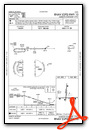
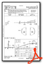
Runway Hdg Length       Surface      ILS Name              ILS ID ILS Freq ILS Hdg Open/Closed
01     4   3469 x 70    Asphalt                                                    Open
19     184 3469 x 70    Asphalt                                                    Open
28     269 3764 x 64    Asphalt                                                    Open
10     89  3764 x 64    Asphalt                                                    Open
============
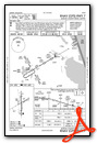
Alpena County Regional Airport (KAPN)
| Automated Surface Observing Systems: | 120.675 Mhz |
| Automatic Terminal Information Service: | 120.675 Mhz |
| Unicom: | 122.950 Mhz |
| Elevation: | 684 FT |
| Airport Location: | Alpena, Michigan United States (N45° 4' 41.10",W83° 33' 37.09") [Google Maps] |
| Airport Information: | [Skyvector] [Airnav] [FlightAware Arrivals] [FlightAware Departures] [FlightPlanDB Arrivals] [FlightPlanDB Departures] |
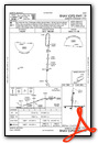
Instrument Approach Procedure (IAP) Charts
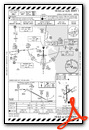


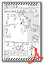
Runway Hdg Length       Surface      ILS Name              ILS ID ILS Freq ILS Hdg Open/Closed
07     60  5026 x 98    Cement                                                     Open
25     240 5026 x 98    Cement                                                     Open
01     360 8978 x 148   Cement       ILS RW01              IAPN   109.700  359     Open
19     180 8978 x 148   Cement                                                     Open
============
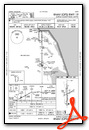
Pike River Landing (79MI)
| Common Traffic Advisory Frequency: | 122.900 Mhz |
| Elevation: | 804 FT |
| Airport Location: | Chassell, Michigan United States (N46° 58' 49.39",W88° 32' 55.42") [Google Maps] |
| Airport Information: | [Skyvector] [Airnav] [FlightAware Arrivals] [FlightAware Departures] [FlightPlanDB Arrivals] [FlightPlanDB Departures] |
Runway Hdg Length       Surface      ILS Name              ILS ID ILS Freq ILS Hdg Open/Closed
19     181 1214 x 82    Grass                                                      Open
01     1   1214 x 82    Grass                                                      Open
07     66  2200 x 82    Grass                                                      Open
25     246 2200 x 82    Grass                                                      Open
============
Marlette Township Airport (77G)
| Unicom: | 122.800 Mhz |
| Elevation: | 879 FT |
| Airport Location: | Marlette, Michigan United States (N43° 18' 42.60",W83° 5' 27.31") [Google Maps] |
| Airport Information: | [Skyvector] [Airnav] [FlightAware Arrivals] [FlightAware Departures] [FlightPlanDB Arrivals] [FlightPlanDB Departures] |
Instrument Approach Procedure (IAP) Charts
Runway Hdg Length       Surface      ILS Name              ILS ID ILS Freq ILS Hdg Open/Closed
01     4   3469 x 70    Asphalt                                                    Open
19     184 3469 x 70    Asphalt                                                    Open
28     269 3764 x 64    Asphalt                                                    Open
10     89  3764 x 64    Asphalt                                                    Open
============
Leg 1  > 77G  to KAPN > R/wy ?? 07/25, 01(ILS)/19 (108nm)   [FlightAware Flights] [FlightAware IFR Analyzer] [FlightPlanDB Routes]
Leg 2  > KAPN to 79MI > R/wy ?? 07/25, 19/01 (237nm)   [FlightAware Flights] [FlightAware IFR Analyzer] [FlightPlanDB Routes]
Leg 3  > 79MI to 77G  > R/wy ?? 01/19, 28/10 (319nm)   [FlightAware Flights] [FlightAware IFR Analyzer] [FlightPlanDB Routes]
