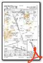
KGCY (Greeneville Greene Co Muni in Greeneville, United States)
NC06 (Elk River in Banner Elk, United States)
KGEV (Ashe County in Jefferson, United States)
KUKF (Wilkes Co in North Wilkesboro, United States)
KMWK (Mt Airy Surry Co in Mount Airy, United States)
KGSO (Piedmont Triad Intl in Greensboro, United States)
KHLX (Twin County in Galax Hillsville, United States)
KBCB (Virginia Tech Montgomery Executive in Blacksburg, United States)
KLWB (Greenbrier Valley in Lewisburg, United States)
KSXL (Summersville in Summersville, United States)
KEKN (Elkins-Randolph Co-Jennings Randolph Field in Elkins, United States)
KCKB (Harrison Marion Rgnl in Clarksburg, United States)
KMGW (Morgantown Muni Walter L Bill Hart Fld in Morgantown, United States)
KWAY (Greene Co in Waynesburg, United States)
Click "Copy Link" to copy to your clipboard:

Click button to download a .PLN file of these hops.

Airport Codes:
KAVL-KGCY-NC06-KGEV-KUKF-KMWK-KGSO-KHLX-KBCB-KLWB-KSXL-KEKN-KCKB-KMGW-KWAY
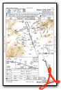
STARTING AIRPORT "Asheville Regl / KAVL"
============
Asheville Regl (KAVL)
| Automatic Terminal Information Service: | 120.200 Mhz |
| Unicom: | 122.950 Mhz |
| Elevation: | 2162 FT |
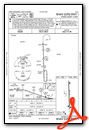
Instrument Approach Procedure (IAP) Charts

Departure Procedure (DP) Charts

Runway Hdg Length       Surface      ILS Name              ILS ID ILS Freq ILS Hdg Open/Closed
17     160 6968 x 101   Asphalt                                                    Open
35     340 6968 x 101   Asphalt                                                    Open
16     160 8012 x 160   Gravel                                                     Open
34     340 8012 x 160   Gravel                                                     Open
============
Greeneville Greene Co Muni (KGCY)
| Automated Weather Observing System: | 128.425 Mhz |
| Unicom: | 122.700 Mhz |
| Elevation: | 1606 FT |
Instrument Approach Procedure (IAP) Charts

Runway Hdg Length       Surface      ILS Name              ILS ID ILS Freq ILS Hdg Open/Closed
5      47  6299 x 100   Asphalt                                                    Open
23     227 6299 x 100   Asphalt                                                    Open
============
Elk River (NC06)
| Unicom: | 122.975 Mhz |
| Elevation: | 3467 FT |
Runway Hdg Length       Surface      ILS Name              ILS ID ILS Freq ILS Hdg Open/Closed
12     119 4613 x 75    Asphalt                                                    Open
30     299 4613 x 75    Asphalt                                                    Open
============
Ashe County (KGEV)
| Automated Weather Observing System: | 120.675 Mhz |
| Unicom: | 122.800 Mhz |
| Elevation: | 3178 FT |
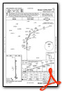
Instrument Approach Procedure (IAP) Charts

Runway Hdg Length       Surface      ILS Name              ILS ID ILS Freq ILS Hdg Open/Closed
10     89  4990 x 75    Asphalt                                                    Open
28     269 4990 x 75    Asphalt                                                    Open
============
Wilkes Co (KUKF)
| Automated Weather Observing System: | 126.625 Mhz |
| Unicom: | 122.700 Mhz |
| Elevation: | 1298 FT |
Instrument Approach Procedure (IAP) Charts


Runway Hdg Length       Surface      ILS Name              ILS ID ILS Freq ILS Hdg Open/Closed
01     359 6212 x 97    Asphalt                                                    Open
19     179 6212 x 97    Asphalt                                                    Open
============
Mt Airy Surry Co (KMWK)
| Automated Weather Observing System: | 121.125 Mhz |
| Unicom: | 123.000 Mhz |
| Elevation: | 1247 FT |
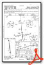
Instrument Approach Procedure (IAP) Charts

Runway Hdg Length       Surface      ILS Name              ILS ID ILS Freq ILS Hdg Open/Closed
18     173 4304 x 75    Asphalt                                                    Open
36     353 4304 x 75    Asphalt                                                    Open
============
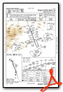
Piedmont Triad Intl (KGSO)
| Automatic Terminal Information Service: | 128.550 Mhz |
| Unicom: | 122.950 Mhz |
| Elevation: | 923 FT |
Standard Terminal Arrival (STAR) Charts


Instrument Approach Procedure (IAP) Charts
- ILS OR LOC RWY 05L
- ILS OR LOC RWY 05R

- ILS OR LOC RWY 23L

- ILS OR LOC RWY 23R
- ILS Y OR LOC Y RWY 32

- ILS Z OR LOC Z RWY 32

- ILS RWY 23L (CAT II)
- ILS RWY 05L (CAT II - III)
- ILS RWY 05R (SA CAT II)
- RNAV (GPS) RWY 05L

- RNAV (GPS) RWY 05R

- RNAV (GPS) RWY 14

- RNAV (GPS) RWY 23L
- RNAV (GPS) RWY 23R

- RNAV (GPS) RWY 32

- VOR/DME RWY 23L

Departure Procedure (DP) Charts

Runway Hdg Length       Surface      ILS Name              ILS ID ILS Freq ILS Hdg Open/Closed
14     135 6379 x 150   Asphalt                                                    Open
32     315 6379 x 150   Asphalt                                                    Open
05L    46  8998 x 150   Asphalt                                                    Open
23R    226 8998 x 150   Asphalt                                                    Open
05R    46  9999 x 150   Asphalt                                                    Open
23L    226 9999 x 150   Asphalt                                                    Open
============
Twin County (KHLX)
| Automated Weather Observing System: | 118.375 Mhz |
| Unicom: | 122.800 Mhz |
| Elevation: | 2692 FT |
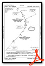
Instrument Approach Procedure (IAP) Charts


Runway Hdg Length       Surface      ILS Name              ILS ID ILS Freq ILS Hdg Open/Closed
01     359 4167 x 75    Asphalt                                                    Open
19     179 4167 x 75    Asphalt                                                    Open
============
Virginia Tech Montgomery Executive (KBCB)
| Automated Weather Observing System: | 133.325 Mhz |
| Unicom: | 123.050 Mhz |
| Elevation: | 2130 FT |
Instrument Approach Procedure (IAP) Charts


Departure Procedure (DP) Charts

Runway Hdg Length       Surface      ILS Name              ILS ID ILS Freq ILS Hdg Open/Closed
12     117 4685 x 98    Asphalt                                                    Open
30     297 4685 x 98    Asphalt                                                    Open
============
Greenbrier Valley (KLWB)
| Automated Weather Observing System: | 121.400 Mhz |
| Unicom: | 118.900 Mhz |
| Unicom: | 122.950 Mhz |
| Elevation: | 2300 FT |
Instrument Approach Procedure (IAP) Charts


Runway Hdg Length       Surface      ILS Name              ILS ID ILS Freq ILS Hdg Open/Closed
04     35  7005 x 150   Asphalt                                                    Open
22     215 7005 x 150   Asphalt                                                    Open
============
Summersville (KSXL)
| Unicom: | 122.800 Mhz |
| Elevation: | 1819 FT |
Instrument Approach Procedure (IAP) Charts
Runway Hdg Length       Surface      ILS Name              ILS ID ILS Freq ILS Hdg Open/Closed
04     37  3016 x 50    Asphalt                                                    Open
22     217 3016 x 50    Asphalt                                                    Open
============
Elkins-Randolph Co-Jennings Randolph Field (KEKN)
| Automated Surface Observing Systems: | 119.275 Mhz |
| Unicom: | 123.600 Mhz |
| Elevation: | 1986 FT |
Instrument Approach Procedure (IAP) Charts


Runway Hdg Length       Surface      ILS Name              ILS ID ILS Freq ILS Hdg Open/Closed
05     39  4500 x 139   Asphalt                                                    Open
23     219 4500 x 139   Asphalt                                                    Open
14     129 4539 x 139   Asphalt                                                    Open
32     309 4539 x 139   Asphalt                                                    Open
============
Harrison Marion Rgnl (KCKB)
| Automatic Terminal Information Service: | 127.825 Mhz |
| Unicom: | 123.000 Mhz |
| Unicom: | 126.700 Mhz |
| Elevation: | 1216 FT |
Instrument Approach Procedure (IAP) Charts


Runway Hdg Length       Surface      ILS Name              ILS ID ILS Freq ILS Hdg Open/Closed
03     23  7005 x 150   Asphalt                                                    Open
21     203 7005 x 150   Asphalt                                                    Open
============
Morgantown Muni Walter L Bill Hart Fld (KMGW)
| Automated Surface Observing Systems: | 120.675 Mhz |
| Unicom: | 122.950 Mhz |
| Unicom: | 125.100 Mhz |
| Elevation: | 1248 FT |
Instrument Approach Procedure (IAP) Charts


Runway Hdg Length       Surface      ILS Name              ILS ID ILS Freq ILS Hdg Open/Closed
05     45  3003 x 75    Asphalt                                                    Open
23     225 3003 x 75    Asphalt                                                    Open
18     172 5205 x 150   Asphalt                                                    Open
36     352 5205 x 150   Asphalt                                                    Open
============
Greene Co (KWAY)
| Unicom: | 122.800 Mhz |
| Elevation: | 1064 FT |
Instrument Approach Procedure (IAP) Charts


Runway Hdg Length       Surface      ILS Name              ILS ID ILS Freq ILS Hdg Open/Closed
09     79  3477 x 75    Asphalt                                                    Open
27     259 3477 x 75    Asphalt                                                    Open
============
Leg 1  - KAVL - KGCY - (48nm)
Leg 2  - KGCY - NC06 - (44nm)
Leg 3  - NC06 - KGEV - (28nm)
Leg 4  - KGEV - KUKF - (20nm)
Leg 5  - KUKF - KMWK - (30nm)
Leg 6  - KMWK - KGSO - (37nm)
Leg 7  - KGSO - KHLX - (58nm)
Leg 8  - KHLX - KBCB - (33nm)
Leg 9  - KBCB - KLWB - (39nm)
Leg 10 - KLWB - KSXL - (32nm)
Leg 11 - KSXL - KEKN - (62nm)
Leg 12 - KEKN - KCKB - (30nm)
Leg 13 - KCKB - KMGW - (25nm)
Leg 14 - KMGW - KWAY - (18nm)
