11S (Sekiu Airport in Sekiu, Washington United States)
KCLM (William R Fairchild International Airport in Port Angeles, Washington United States)
0S9 (Jefferson County International Airport in Port Townsend, Washington United States)
8W5 (Apex Airpark in Silverdale, Washington )
KPAE (Seattle Paine Field International Airport in Everett, Washington United States)
WA56 (Israel's Farm Airport in Sedro Woolley, Washington United States) No Parking/Gates!
KNUW (Whidbey Island Naval Air Station (Ault Field) in Oak Harbor, Washington United States)
KORS (Orcas Island Airport in Eastsound, Washington United States)
CYYJ (Victoria International Airport in Victoria, British Columbia Canada)
4W6 (Blaine Municipal Airport in Blaine, Washington United States) No Parking/Gates!
CYVR (Vancouver International Airport in Vancouver, British Columbia Canada)
CYSE (Squamish Airport in Squamish, British Columbia Canada)
CAP3 (Sechelt-Gibsons Airport in Sechelt, British Columbia Canada)
CYGB (Texada Gillies Bay Airport in Texada, British Columbia Canada)
CBS8 (Alberni Valley Regional Airport in Port Alberni, British Columbia Canada)
CAT4 (Qualicum Beach Airport in Qualicum Beach, British Columbia Canada)
CYCD (Nanaimo Airport in Nanaimo, British Columbia Canada)
CAM3 (Duncan Airport in Duncan, British Columbia Canada)
KFHR (Friday Harbor Airport in Friday Harbor, Washington United States) [ADDON Airport! Scenery may be required!]
KBLI (Bellingham International Airport in Bellingham, Washington United States)
Click "Copy Link" to copy to your clipboard:

Click button to download a .PLN file of these hops.

Airport Codes:
KUIL-11S-KCLM-0S9-8W5-KPAE-WA56-KNUW-KORS-CYYJ-4W6-CYVR-CYSE-CAP3-CYGB-CBS8-CAT4-CYCD-CAM3-KFHR-KBLI
STARTING AIRPORT "Quillayute Airport / KUIL"
============
Quillayute Airport (KUIL)
[FlightAware Arrivals] [FlightAware Departures] [FlightPlanDB Arrivals] [FlightPlanDB Departures]
| Automated Weather Observing System: | 135.225 Mhz |
| Common Traffic Advisory Frequency: | 122.900 Mhz |
| Elevation: | 182 FT |
Runway Hdg Length       Surface      ILS Name              ILS ID ILS Freq ILS Hdg Open/Closed
04     58  4189 x 97    Cement                                                     Open
22     238 4189 x 97    Cement                                                     Open
31     323 4571 x 186   Cement                                                     Closed
13     143 4571 x 186   Cement                                                     Closed
============
Sekiu Airport (11S)
[FlightAware Arrivals] [FlightAware Departures] [FlightPlanDB Arrivals] [FlightPlanDB Departures]
| Common Traffic Advisory Frequency: | 122.900 Mhz |
| Elevation: | 333 FT |
Runway Hdg Length       Surface      ILS Name              ILS ID ILS Freq ILS Hdg Open/Closed
08     101 2997 x 51    Asphalt                                                    Open
26     281 2997 x 51    Asphalt                                                    Open
============
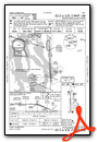
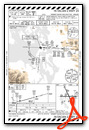
William R Fairchild International Airport (KCLM)
[FlightAware Arrivals] [FlightAware Departures] [FlightPlanDB Arrivals] [FlightPlanDB Departures]
| Automated Surface Observing Systems: | 135.170 Mhz |
| Common Traffic Advisory Frequency: | 122.975 Mhz |
| Unicom: | 122.975 Mhz |
| Unicom: | 123.000 Mhz |
| Elevation: | 266 FT |
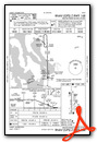
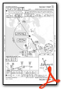
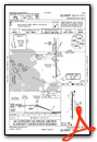
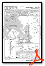
Instrument Approach Procedure (IAP) Charts

Runway Hdg Length       Surface      ILS Name              ILS ID ILS Freq ILS Hdg Open/Closed
13     148 3242 x 50    Bituminous                                                 Open
31     328 3242 x 50    Bituminous                                                 Open
08     105 6350 x 142   Asphalt                                                    Open
26     285 6350 x 142   Asphalt                                                    Open
============
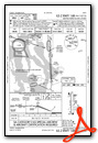
Jefferson County International Airport (0S9)
[FlightAware Arrivals] [FlightAware Departures] [FlightPlanDB Arrivals] [FlightPlanDB Departures]
| Automated Weather Observing System: | 119.025 Mhz |
| Unicom: | 123.000 Mhz |
| Elevation: | 108 FT |
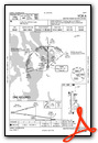
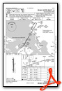
Instrument Approach Procedure (IAP) Charts
Runway Hdg Length       Surface      ILS Name              ILS ID ILS Freq ILS Hdg Open/Closed
09     104 2999 x 71    Bituminous                                                 Open
27     284 2999 x 71    Bituminous                                                 Open
============
Apex Airpark (8W5)
[FlightAware Arrivals] [FlightAware Departures] [FlightPlanDB Arrivals] [FlightPlanDB Departures]
| Common Traffic Advisory Frequency: | 122.800 Mhz |
| Unicom: | 122.800 Mhz |
| Elevation: | 510 FT |
Runway Hdg Length       Surface      ILS Name              ILS ID ILS Freq ILS Hdg Open/Closed
17     188 2568 x 26    Asphalt                                                    Open
35     8   2568 x 26    Asphalt                                                    Open
============
Seattle Paine Field International Airport (KPAE)
[FlightAware Arrivals] [FlightAware Departures] [FlightPlanDB Arrivals] [FlightPlanDB Departures]
| Automatic Terminal Information Service: | 128.650 Mhz |
| Unicom: | 122.950 Mhz |
| Elevation: | 586 FT |
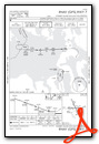
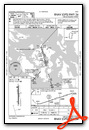
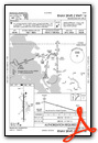
Standard Terminal Arrival (STAR) Charts
Instrument Approach Procedure (IAP) Charts

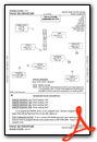
Departure Procedure (DP) Charts
Runway Hdg Length       Surface      ILS Name              ILS ID ILS Freq ILS Hdg Open/Closed
16L    180 3003 x 76    Asphalt                                                    Open
34R    360 3003 x 76    Asphalt                                                    Open
16R    179 9399 x 147   Asphalt      ILS RW16R             IPAE   109.300  179     Open
34L    359 9399 x 147   Asphalt                                                    Open
============
Israel's Farm Airport (WA56)
[FlightAware Arrivals] [FlightAware Departures] [FlightPlanDB Arrivals] [FlightPlanDB Departures]
| Elevation: | 61 FT |
Runway Hdg Length       Surface      ILS Name              ILS ID ILS Freq ILS Hdg Open/Closed
21     221 1494 x 57    Grass                                                      Open
03     41  1494 x 57    Grass                                                      Open
============
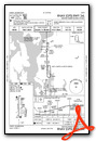
Whidbey Island Naval Air Station (Ault Field) (KNUW)
[FlightAware Arrivals] [FlightAware Departures] [FlightPlanDB Arrivals] [FlightPlanDB Departures]
| Automatic Terminal Information Service: | 134.150 Mhz |
| Elevation: | 32 FT |
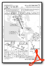
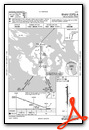
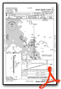
Instrument Approach Procedure (IAP) Charts


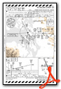

Runway Hdg Length       Surface      ILS Name              ILS ID ILS Freq ILS Hdg Open/Closed
14     155 7953 x 200   Asphalt      ILS RW14              INUW   110.100  154     Open
32     335 7953 x 200   Asphalt                                                    Open
07     87  7962 x 183   Asphalt                                                    Open
25     267 7962 x 183   Asphalt                                                    Open
============
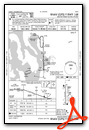
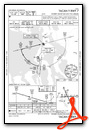
Orcas Island Airport (KORS)
[FlightAware Arrivals] [FlightAware Departures] [FlightPlanDB Arrivals] [FlightPlanDB Departures]
| Automated Weather Observing System: | 135.425 Mhz |
| Common Traffic Advisory Frequency: | 128.250 Mhz |
| Elevation: | 23 FT |
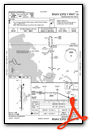
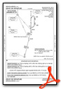
Instrument Approach Procedure (IAP) Charts
Departure Procedure (DP) Charts
Runway Hdg Length       Surface      ILS Name              ILS ID ILS Freq ILS Hdg Open/Closed
16     180 2891 x 51    Bituminous                                                 Open
34     0   2891 x 51    Bituminous                                                 Open
============
Victoria International Airport (CYYJ)
[FlightAware Arrivals] [FlightAware Departures] [FlightPlanDB Arrivals] [FlightPlanDB Departures]
| Automatic Terminal Information Service: | 118.800 Mhz |
| Elevation: | 53 FT |
Runway Hdg Length       Surface      ILS Name              ILS ID ILS Freq ILS Hdg Open/Closed
14     152 4976 x 199   Asphalt                                                    Open
32     332 4976 x 199   Asphalt                                                    Open
21     224 5035 x 204   Asphalt                                                    Open
03     44  5035 x 204   Asphalt                                                    Open
09     106 6966 x 210   Asphalt      ILS RW09              IKH    108.700  106     Open
27     286 6966 x 210   Asphalt      ILS RW27              IYJ    109.950  286     Open
============
Blaine Municipal Airport (4W6)
[FlightAware Arrivals] [FlightAware Departures] [FlightPlanDB Arrivals] [FlightPlanDB Departures]
| Elevation: | 69 FT |
Runway Hdg Length       Surface      ILS Name              ILS ID ILS Freq ILS Hdg Open/Closed
15     161 1049 x 47    Asphalt                                                    Open
33     341 1049 x 47    Asphalt                                                    Open
============
Vancouver International Airport (CYVR)
[FlightAware Arrivals] [FlightAware Departures] [FlightPlanDB Arrivals] [FlightPlanDB Departures]
| Automatic Terminal Information Service: | 124.600 Mhz |
| Elevation: | 9 FT |
Runway Hdg Length       Surface      ILS Name              ILS ID ILS Freq ILS Hdg Open/Closed
31     322 7497 x 198   Asphalt                                                    Open
13     142 7497 x 198   Asphalt      ILS RW13              IMK    111.100  141     Open
26R    280 9949 x 209   Cement       ILS RW26R             IRD    111.950  279     Open
08L    100 9949 x 209   Cement       ILS RW08L             ITL    110.550  99      Open
26L    280 12187 x 221  Cement       ILS RW26L             IFZ    110.700  279     Open
08R    100 12187 x 221  Cement       ILS RW08R             IVR    109.500  99      Open
============
Squamish Airport (CYSE)
[FlightAware Arrivals] [FlightAware Departures] [FlightPlanDB Arrivals] [FlightPlanDB Departures]
| Elevation: | 171 FT |
Runway Hdg Length       Surface      ILS Name              ILS ID ILS Freq ILS Hdg Open/Closed
15     165 2390 x 72    Asphalt                                                    Open
33     345 2390 x 72    Asphalt                                                    Open
============
Sechelt-Gibsons Airport (CAP3)
[FlightAware Arrivals] [FlightAware Departures] [FlightPlanDB Arrivals] [FlightPlanDB Departures]
| Elevation: | 295 FT |
Runway Hdg Length       Surface      ILS Name              ILS ID ILS Freq ILS Hdg Open/Closed
29     312 2376 x 67    Asphalt                                                    Open
11     132 2376 x 67    Asphalt                                                    Open
============
Texada Gillies Bay Airport (CYGB)
[FlightAware Arrivals] [FlightAware Departures] [FlightPlanDB Arrivals] [FlightPlanDB Departures]
| Elevation: | 326 FT |
Runway Hdg Length       Surface      ILS Name              ILS ID ILS Freq ILS Hdg Open/Closed
14     159 2964 x 73    Asphalt                                                    Open
32     339 2964 x 73    Asphalt                                                    Open
============
Alberni Valley Regional Airport (CBS8)
[FlightAware Arrivals] [FlightAware Departures] [FlightPlanDB Arrivals] [FlightPlanDB Departures]
| Elevation: | 243 FT |
Runway Hdg Length       Surface      ILS Name              ILS ID ILS Freq ILS Hdg Open/Closed
30     315 5002 x 96    Asphalt                                                    Open
12     135 5002 x 96    Asphalt                                                    Open
============
Qualicum Beach Airport (CAT4)
[FlightAware Arrivals] [FlightAware Departures] [FlightPlanDB Arrivals] [FlightPlanDB Departures]
| Elevation: | 176 FT |
Runway Hdg Length       Surface      ILS Name              ILS ID ILS Freq ILS Hdg Open/Closed
11     128 3559 x 69    Asphalt                                                    Open
29     308 3559 x 69    Asphalt                                                    Open
============
Nanaimo Airport (CYCD)
[FlightAware Arrivals] [FlightAware Departures] [FlightPlanDB Arrivals] [FlightPlanDB Departures]
| Automatic Terminal Information Service: | 128.425 Mhz |
| Elevation: | 83 FT |
Runway Hdg Length       Surface      ILS Name              ILS ID ILS Freq ILS Hdg Open/Closed
34     1   6593 x 131   Asphalt                                                    Open
16     181 6593 x 131   Asphalt      ILS RW16              ICD    110.350  180     Open
============
Duncan Airport (CAM3)
[FlightAware Arrivals] [FlightAware Departures] [FlightPlanDB Arrivals] [FlightPlanDB Departures]
| Elevation: | 300 FT |
Runway Hdg Length       Surface      ILS Name              ILS ID ILS Freq ILS Hdg Open/Closed
13     151 1500 x 27    Bituminous                                                 Open
31     331 1500 x 27    Bituminous                                                 Open
============
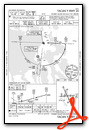
Friday Harbor Airport (KFHR) [ADDON Scenery Required]
[FlightAware Arrivals] [FlightAware Departures] [FlightPlanDB Arrivals] [FlightPlanDB Departures]
| Automated Surface Observing Systems: | 135.675 Mhz |
| Automatic Terminal Information Service: | 135.675 Mhz |
| Common Traffic Advisory Frequency: | 128.250 Mhz |
| Elevation: | 92 FT |
Instrument Approach Procedure (IAP) Charts
Runway Hdg Length       Surface      ILS Name              ILS ID ILS Freq ILS Hdg Open/Closed
16     177 3397 x 75    Asphalt                                                    Open
34     357 3397 x 75    Asphalt                                                    Open
============
Bellingham International Airport (KBLI)
[FlightAware Arrivals] [FlightAware Departures] [FlightPlanDB Arrivals] [FlightPlanDB Departures]
| Automatic Terminal Information Service: | 134.450 Mhz |
| Unicom: | 122.950 Mhz |
| Elevation: | 167 FT |
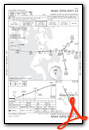
Standard Terminal Arrival (STAR) Charts

Instrument Approach Procedure (IAP) Charts
Departure Procedure (DP) Charts

Runway Hdg Length       Surface      ILS Name              ILS ID ILS Freq ILS Hdg Open/Closed
16     180 6709 x 145   Asphalt      ILS RW16              IBLI   108.500  179     Open
34     360 6709 x 145   Asphalt                                                    Open
============
Leg 1  > KUIL to 11S  > R/wy ?? 08/26 (22nm)    [FlightAware Flights] [FlightAware IFR Analyzer] [FlightPlanDB Routes]
Leg 2  > 11S  to KCLM > R/wy ?? 13/31, 08/26 (34nm)    [FlightAware Flights] [FlightAware IFR Analyzer] [FlightPlanDB Routes]
Leg 3  > KCLM to 0S9  > R/wy ?? 09/27 (28nm)    [FlightAware Flights] [FlightAware IFR Analyzer] [FlightPlanDB Routes]
Leg 4  > 0S9  to 8W5  > R/wy ?? 17/35 (24nm)    [FlightAware Flights] [FlightAware IFR Analyzer] [FlightPlanDB Routes]
Leg 5  > 8W5  to KPAE > R/wy ?? 16L/34R, 16R(ILS)/34L (24nm)    [FlightAware Flights] [FlightAware IFR Analyzer] [FlightPlanDB Routes]
Leg 6  > KPAE to WA56 > R/wy ?? 21/03 (37nm)    [FlightAware Flights] [FlightAware IFR Analyzer] [FlightPlanDB Routes]
Leg 7  > WA56 to KNUW > R/wy ?? 14(ILS)/32, 07/25 (24nm)    [FlightAware Flights] [FlightAware IFR Analyzer] [FlightPlanDB Routes]
Leg 8  > KNUW to KORS > R/wy ?? 16/34 (24nm)    [FlightAware Flights] [FlightAware IFR Analyzer] [FlightPlanDB Routes]
Leg 9  > KORS to CYYJ > R/wy ?? 09(ILS)/27(ILS), 14/32, 21/03 (21nm)    [FlightAware Flights] [FlightAware IFR Analyzer] [FlightPlanDB Routes]
Leg 10 > CYYJ to 4W6  > R/wy ?? 15/33 (34nm)    [FlightAware Flights] [FlightAware IFR Analyzer] [FlightPlanDB Routes]
Leg 11 > 4W6  to CYVR > R/wy ?? 26L(ILS)/08R(ILS), 26R(ILS)/08L(ILS), 31/13(ILS) (21nm)    [FlightAware Flights] [FlightAware IFR Analyzer] [FlightPlanDB Routes]
Leg 12 > CYVR to CYSE > R/wy ?? 15/33 (35nm)    [FlightAware Flights] [FlightAware IFR Analyzer] [FlightPlanDB Routes]
Leg 13 > CYSE to CAP3 > R/wy ?? 29/11 (29nm)    [FlightAware Flights] [FlightAware IFR Analyzer] [FlightPlanDB Routes]
Leg 14 > CAP3 to CYGB > R/wy ?? 14/32 (34nm)    [FlightAware Flights] [FlightAware IFR Analyzer] [FlightPlanDB Routes]
Leg 15 > CYGB to CBS8 > R/wy ?? 30/12 (28nm)    [FlightAware Flights] [FlightAware IFR Analyzer] [FlightPlanDB Routes]
Leg 16 > CBS8 to CAT4 > R/wy ?? 11/29 (21nm)    [FlightAware Flights] [FlightAware IFR Analyzer] [FlightPlanDB Routes]
Leg 17 > CAT4 to CYCD > R/wy ?? 34/16(ILS) (27nm)    [FlightAware Flights] [FlightAware IFR Analyzer] [FlightPlanDB Routes]
Leg 18 > CYCD to CAM3 > R/wy ?? 13/31 (19nm)    [FlightAware Flights] [FlightAware IFR Analyzer] [FlightPlanDB Routes]
Leg 19 > CAM3 to KFHR > R/wy ?? 16/34 (31nm)    [FlightAware Flights] [FlightAware IFR Analyzer] [FlightPlanDB Routes]
Leg 20 > KFHR to KBLI > R/wy ?? 16(ILS)/34 (25nm)    [FlightAware Flights] [FlightAware IFR Analyzer] [FlightPlanDB Routes]
