KORG (Orange County Airport in Orange, Texas United States)
KLCH (Lake Charles Regional Airport in Lake Charles, Louisiana United States)
3R7 (Jennings Airport in Jennings, Louisiana United States)
KLFT (Lafayette Regional Airport in Lafayette, Louisiana United States)
KBTR (Baton Rouge Metropolitan Airport in Baton Rouge, Louisiana United States)
KAPS (St John The Baptist Parish in Reserve, Louisiana )
KHDC (Hammond Northshore Regional Airport in Hammond, Louisiana United States)
KMSY (Louis Armstrong New Orleans International Airport in New Orleans, Louisiana United States)
KHSA (Stennis International Airport in Bay St Louis, Mississippi United States)
KGPT (Gulfport Biloxi International Airport in Gulfport, Mississippi United States)
KPQL (Trent Lott International Airport in Pascagoula, Mississippi United States)
KBFM (Mobile Downtown Airport in Mobile, Alabama United States)
KJKA (Jack Edwards National Airport in Gulf Shores, Alabama United States)
KPNS (Pensacola International Airport in Pensacola, Florida United States)
KVPS (Destin-Fort Walton Beach Airport in Valparaiso, Florida United States)
Click "Copy Link" to copy to your clipboard:

Click button to download a .PLN file of these hops.

Airport Codes:
KBPT-KORG-KLCH-3R7-KLFT-KBTR-KAPS-KHDC-KMSY-KHSA-KGPT-KPQL-KBFM-KJKA-KPNS-KVPS
STARTING AIRPORT "Jack Brooks Regional Airport / KBPT"
============
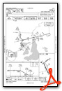
Jack Brooks Regional Airport (KBPT)
| Automated Surface Observing Systems: | 126.300 Mhz |
| Automatic Terminal Information Service: | 126.300 Mhz |
| Unicom: | 122.950 Mhz |
| Elevation: | 12 FT |
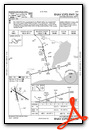
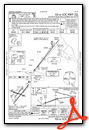
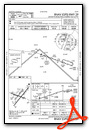
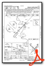
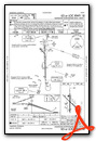
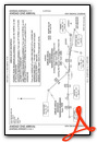
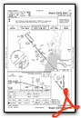
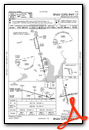
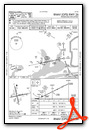
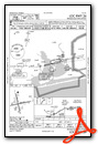
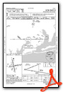
Instrument Approach Procedure (IAP) Charts
Runway Hdg Length Surface ILS Name ILS ID ILS Freq ILS Hdg Open/Closed
16 166 5069 x 143 Asphalt Open
34 346 5069 x 143 Asphalt Open
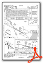
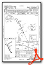
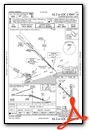
12 121 6748 x 147 Asphalt ILS RW12 IBPT 110.150 121 Open
30 301 6748 x 147 Asphalt Open
============
Orange County Airport (KORG)
| Automated Weather Observing System: | 118.975 Mhz |
| Unicom: | 122.800 Mhz |
| Elevation: | 11 FT |
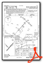
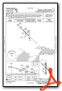
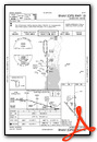
Instrument Approach Procedure (IAP) Charts
Runway Hdg Length       Surface      ILS Name              ILS ID ILS Freq ILS Hdg Open/Closed
13     138 3241 x 50    Grass                                                      Open
31     318 3241 x 50    Grass                                                      Open
04     42  5466 x 70    Asphalt                                                    Open
22     222 5466 x 70    Asphalt                                                    Open
============
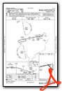
Lake Charles Regional Airport (KLCH)
| Automatic Terminal Information Service: | 118.750 Mhz |
| Unicom: | 122.950 Mhz |
| Elevation: | 11 FT |
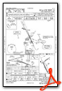
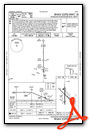
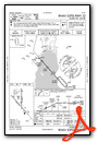
Instrument Approach Procedure (IAP) Charts
Runway Hdg Length Surface ILS Name ILS ID ILS Freq ILS Hdg Open/Closed
05 52 5196 x 100 Asphalt Open
23 232 5196 x 100 Asphalt Open
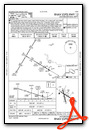
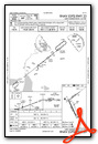
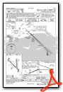
15 155 6514 x 150 Cement ILS RW15 ILCH 109.100 154 Open
33 335 6514 x 150 Cement Open
============
Jennings Airport (3R7)
| Automated Weather Observing System: | 121.150 Mhz |
| Unicom: | 122.800 Mhz |
| Elevation: | 20 FT |
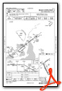
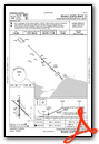
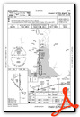
Instrument Approach Procedure (IAP) Charts
Runway Hdg Length       Surface      ILS Name              ILS ID ILS Freq ILS Hdg Open/Closed
13     135 3598 x 72    Bituminous                                                 Open
31     315 3598 x 72    Bituminous                                                 Closed
08     79  4999 x 72    Asphalt                                                    Open
26     259 4999 x 72    Asphalt                                                    Closed
============
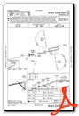
Lafayette Regional Airport (KLFT)
| Automated Surface Observing Systems: | 134.050 Mhz |
| Automatic Terminal Information Service: | 134.050 Mhz |
| Unicom: | 122.950 Mhz |
| Elevation: | 38 FT |
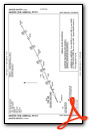
Instrument Approach Procedure (IAP) Charts
Runway Hdg Length Surface ILS Name ILS ID ILS Freq ILS Hdg Open/Closed
04L 39 4100 x 72 Asphalt Open
22R 219 4100 x 72 Asphalt Open
11 110 5397 x 144 Asphalt Open
29 290 5397 x 144 Asphalt Open
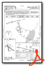
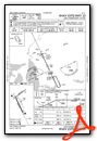
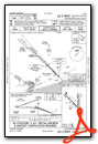
04R 39 8003 x 148 Asphalt ILS RW04R ITYN 110.900 38 Open
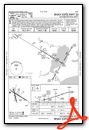
22L 219 8003 x 148 Asphalt ILS RW22L ILFT 109.500 218 Open
============
Baton Rouge Metropolitan Airport (KBTR)
| Automatic Terminal Information Service: | 125.200 Mhz |
| Unicom: | 122.950 Mhz |
| Elevation: | 67 FT |
Instrument Approach Procedure (IAP) Charts
Runway Hdg Length Surface ILS Name ILS ID ILS Freq ILS Hdg Open/Closed
04R 43 3794 x 75 Asphalt Open
22L 223 3794 x 75 Asphalt Open
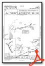
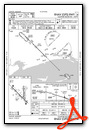
13 134 6983 x 150 Asphalt ILS RW13 IBTR 110.300 133 Closed
31 314 6983 x 150 Asphalt Closed
04L 43 7503 x 150 Asphalt Open
22R 223 7503 x 150 Asphalt ILS RW22R ICLZ 108.700 223 Open
============
St John The Baptist Parish (KAPS)
| Automated Weather Observing System: | 125.450 Mhz |
| Unicom: | 122.700 Mhz |
| Elevation: | 5 FT |
Instrument Approach Procedure (IAP) Charts
Runway Hdg Length       Surface      ILS Name              ILS ID ILS Freq ILS Hdg Open/Closed
17     172 5131 x 70    Bituminous                                                 Open
35     352 5131 x 70    Bituminous                                                 Open
============
Hammond Northshore Regional Airport (KHDC)
| Automatic Terminal Information Service: | 118.325 Mhz |
| Elevation: | 43 FT |
Instrument Approach Procedure (IAP) Charts
Runway Hdg Length       Surface      ILS Name              ILS ID ILS Freq ILS Hdg Open/Closed
18     180 4967 x 147   Cement       ILS RW18              IHPF   111.500  179     Open
36     360 4967 x 147   Cement                                                     Open
13     135 6468 x 89    Asphalt                                                    Open
31     315 6468 x 89    Asphalt                                                    Open
============
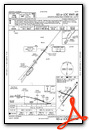
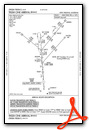
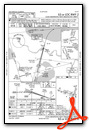
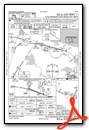
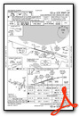
Louis Armstrong New Orleans International Airport (KMSY)
| Automatic Terminal Information Service: | 127.550 Mhz |
| Unicom: | 122.950 Mhz |
| Elevation: | 1 FT |
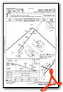
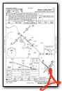
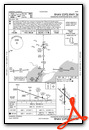
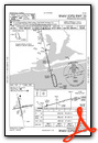
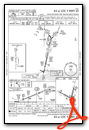
Standard Terminal Arrival (STAR) Charts
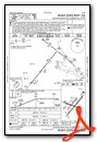
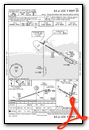
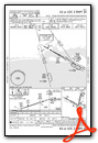
Instrument Approach Procedure (IAP) Charts

Runway Hdg Length       Surface      ILS Name              ILS ID ILS Freq ILS Hdg Open/Closed
02     15  6998 x 148   Cement       ILS RW02              IJFI   111.700  15      Open
20     195 6998 x 148   Cement       ILS RW20              IONW   111.700  195     Open
11     106 10100 x 144  Cement       ILS RW11              IMSY   109.900  105     Open
29     286 10100 x 144  Cement       ILS RW29              IHOX   109.900  285     Open
============
Stennis International Airport (KHSA)
| Automated Weather Observing System: | 118.375 Mhz |
| Unicom: | 122.950 Mhz |
| Elevation: | 18 FT |
Instrument Approach Procedure (IAP) Charts
Runway Hdg Length       Surface      ILS Name              ILS ID ILS Freq ILS Hdg Open/Closed
18     180 8467 x 135   Bituminous   ILS RW18              IHSA   110.350  180     Open
36     0   8467 x 135   Bituminous                                                 Open
============
Gulfport Biloxi International Airport (KGPT)
| Automated Surface Observing Systems: | 119.450 Mhz |
| Automatic Terminal Information Service: | 119.450 Mhz |
| Unicom: | 122.950 Mhz |
| Elevation: | 23 FT |
Instrument Approach Procedure (IAP) Charts

Runway Hdg Length       Surface      ILS Name              ILS ID ILS Freq ILS Hdg Open/Closed
18     180 4926 x 147   Cement                                                     Open
36     360 4926 x 147   Cement                                                     Open
14     135 8996 x 144   Cement       ILS RW14              IGPT   110.900  135     Open
32     315 8996 x 144   Cement       ILS RW32              IUXI   108.300  315     Open
============
Trent Lott International Airport (KPQL)
| Automated Surface Observing Systems: | 135.175 Mhz |
| Automatic Terminal Information Service: | 135.175 Mhz |
| Unicom: | 122.800 Mhz |
| Elevation: | 16 FT |
Instrument Approach Procedure (IAP) Charts
Runway Hdg Length       Surface      ILS Name              ILS ID ILS Freq ILS Hdg Open/Closed
17     166 6465 x 100   Asphalt      ILS RW17              IPQL   110.100  166     Open
35     346 6465 x 100   Asphalt                                                    Open
============
Mobile Downtown Airport (KBFM)
| Automatic Terminal Information Service: | 135.575 Mhz |
| Unicom: | 122.950 Mhz |
| Elevation: | 24 FT |
Instrument Approach Procedure (IAP) Charts
Runway Hdg Length       Surface      ILS Name              ILS ID ILS Freq ILS Hdg Open/Closed
18     180 7795 x 144   Asphalt                                                    Open
36     360 7795 x 144   Asphalt                                                    Closed
14     139 9617 x 137   Asphalt                                                    Open
32     319 9617 x 137   Asphalt      ILS RW32              IRUJ   108.500  318     Open
============
Jack Edwards National Airport (KJKA)
| Automatic Terminal Information Service: | 134.525 Mhz |
| Unicom: | 122.700 Mhz |
| Elevation: | 15 FT |
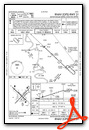
Instrument Approach Procedure (IAP) Charts
Runway Hdg Length       Surface      ILS Name              ILS ID ILS Freq ILS Hdg Open/Closed
17     175 3587 x 74    Asphalt                                                    Open
35     355 3587 x 74    Asphalt                                                    Open
09     90  6963 x 91    Asphalt                                                    Open
27     270 6963 x 91    Asphalt      ILS RW27              IJKA   110.700  269     Open
============
Pensacola International Airport (KPNS)
| Automated Surface Observing Systems: | 121.250 Mhz |
| Automatic Terminal Information Service: | 121.250 Mhz |
| Unicom: | 122.950 Mhz |
| Elevation: | 108 FT |
Instrument Approach Procedure (IAP) Charts
Runway Hdg Length       Surface      ILS Name              ILS ID ILS Freq ILS Hdg Open/Closed
08     78  6992 x 147   Asphalt                                                    Open
26     258 6992 x 147   Asphalt      ILS RW26              IPHC   110.950  258     Open
17     167 6993 x 146   Cement       ILS RW17              IPNS   111.100  167     Open
35     347 6993 x 146   Cement                                                     Open
============
Destin-Fort Walton Beach Airport (KVPS)
| Automatic Terminal Information Service: | 134.625 Mhz |
| Elevation: | 60 FT |
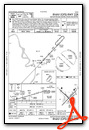
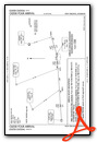
Instrument Approach Procedure (IAP) Charts


Runway Hdg Length       Surface      ILS Name              ILS ID ILS Freq ILS Hdg Open/Closed
01     12  9992 x 145   Asphalt                                                    Open
19     192 9992 x 145   Asphalt                                                    Open
12     120 11995 x 139  Asphalt                                                    Open
30     300 11995 x 139  Asphalt      ILS RW30              IVPS   109.100  297     Open
============
Leg 1  - KBPT - KORG - (13nm)
Leg 2  - KORG - KLCH - (30nm)
Leg 3  - KLCH - 3R7  - (29nm)
Leg 4  - 3R7  - KLFT - (36nm)
Leg 5  - KLFT - KBTR - (48nm)
Leg 6  - KBTR - KAPS - (40nm)
Leg 7  - KAPS - KHDC - (27nm)
Leg 8  - KHDC - KMSY - (33nm)
Leg 9  - KMSY - KHSA - (47nm)
Leg 10 - KHSA - KGPT - (20nm)
Leg 11 - KGPT - KPQL - (28nm)
Leg 12 - KPQL - KBFM - (26nm)
Leg 13 - KBFM - KJKA - (29nm)
Leg 14 - KJKA - KPNS - (27nm)
Leg 15 - KPNS - KVPS - (34nm)
