KOTG (Worthington Mun in Worthington, Minnesota United States)
Click "Copy Link" to copy to your clipboard:

Click button to download a .PLN file of these hops.

Airport Codes:
KBOI-KOTG
STARTING AIRPORT "Boise Air Terminal/Gowen / KBOI"
============
Boise Air Terminal/Gowen (KBOI)
| Automatic Terminal Information Service: | 123.900 Mhz |
| Unicom: | 122.950 Mhz |
| Elevation: | 2871 FT |
| Airport Location: | Boise, Idaho United States (N43° 33' 51.70",W116° 13' 22.30") [Google Maps] |
| Airport Information: | [Skyvector] [Airnav] [VFR Chart] [Low Alt. IFR] [High Alt. IFR] [iFlightPlanner Info] [iFlightPlanner Map] [FlightAware Arrivals] [FlightAware Departures] [FlightPlanDB Arrivals] [FlightPlanDB Departures] |
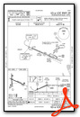
Standard Terminal Arrival (STAR) Charts
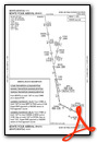

Instrument Approach Procedure (IAP) Charts
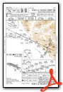
- HI-ILS Z OR LOC Z RWY 10R
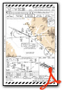
- ILS OR LOC RWY 28R
- ILS Y OR LOC Y RWY 10R
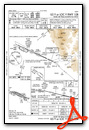
- ILS Y RWY 10R (SA CAT I)

- ILS Y RWY 10R (CAT II - III)
- RNAV (RNP) X RWY 28L
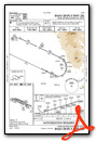
- RNAV (RNP) X RWY 28R
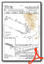
- RNAV (RNP) Z RWY 10L
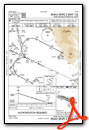
- RNAV (RNP) Z RWY 10R
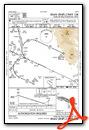
- RNAV (RNP) Z RWY 28L
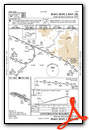
- RNAV (RNP) Z RWY 28R
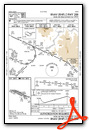
- RNAV (GPS) Y RWY 10L
- RNAV (GPS) Y RWY 10R
- RNAV (GPS) Y RWY 28L
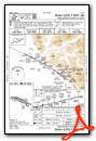
- RNAV (GPS) Y RWY 28R
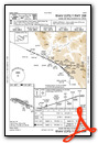
- HI-VOR Z OR TACAN Z RWY 28L
- HI-VOR OR TACAN RWY 10R
- VOR OR TACAN RWY 10L

- VOR Y OR TACAN Y RWY 28L
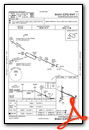
Departure Procedure (DP) Charts

Runway Hdg Length       Surface      ILS Name              ILS ID ILS Freq ILS Hdg Open/Closed
10R    115 9750 x 150   Asphalt      ILS/DME 10R           IBOI   111.100  115     Open
28L    295 9750 x 150   Asphalt                                                    Open
10L    115 9986 x 150   Asphalt                                                    Open
28R    295 9986 x 150   Asphalt                                                    Open
============
Worthington Mun (KOTG)
| Common Traffic Advisory Frequency: | 122.800 Mhz |
| Unicom: | 122.800 Mhz |
| Elevation: | 1574 FT |
| Airport Location: | Worthington, Minnesota United States (N43° 39' 18.20",W95° 34' 45.21") [Google Maps] |
| Airport Information: | [Skyvector] [Airnav] [VFR Chart] [Low Alt. IFR] [High Alt. IFR] [iFlightPlanner Info] [iFlightPlanner Map] [FlightAware Arrivals] [FlightAware Departures] [FlightPlanDB Arrivals] [FlightPlanDB Departures] |
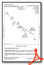
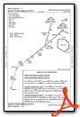
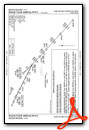
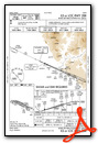
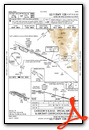
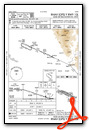
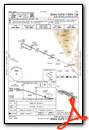
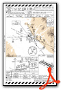
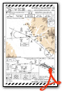
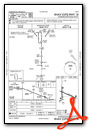
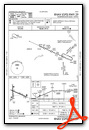
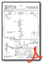
Instrument Approach Procedure (IAP) Charts
Runway Hdg Length       Surface      ILS Name              ILS ID ILS Freq ILS Hdg Open/Closed
17     180 4202 x 100   Asphalt                                                    Open
35     360 4202 x 100   Asphalt                                                    Open
11     115 5499 x 100   Asphalt                                                    Open
29     295 5499 x 100   Asphalt      ILS 29                IOTG   111.700  294     Open
============
Leg 1 > KBOI to KOTG > R/wy ?? 11/29(ILS), 17/35 (894nm) [FlightAware Flights] [FlightAware IFR Analyzer] [FlightPlanDB Routes]
