80A (American Creek in American Creek, Alaska )
83AK (Tolovana Hot Springs Airport in Fairbanks, Alaska United States)
PAFA (Fairbanks International Airport in Fairbanks, Alaska United States)
0AK0 (Scotts Airport in Salcha, Alaska United States)
AA22 (Delta Daves Airport in Delta Junction, Alaska United States)
5BK (Black Rapids Airport in Black Rapids, Alaska United States)
4AK5 (Mankomen Lake Airport in Mankomen Lake, Alaska United States) No Parking/Gates!
PADB (Deltana Airport in Deltana, ) No Parking/Gates!
8AK1 (Jacobus Field in Gulkana, Alaska United States) No Parking/Gates!
Z93 (Copper Center 2 Airport in Copper Center, Alaska United States)
HNE (Tahneta Pass Airport in Tahneta Pass Lodge, Alaska United States) No Parking/Gates!
52AK (Basquo Airport in Kenai, Alaska United States)
9AK8 (Wolf Track Airport in Wasilla, Alaska United States)
49AK (Secluded Lake Airport in Talkeetna, Alaska United States)
3AK3 (Songlo Vista Airport in Talkeetna, Alaska United States)
Click "Copy Link" to copy to your clipboard:

Click button to download a .PLN file of these hops.

Airport Codes:
PATA-80A-83AK-PAFA-0AK0-AA22-5BK-4AK5-PADB-8AK1-Z93-HNE-52AK-9AK8-49AK-3AK3
STARTING AIRPORT "Ralph M Calhoun Memorial Airport / PATA"
============
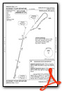
Ralph M Calhoun Memorial Airport (PATA)
| Automated Surface Observing Systems: | 135.100 Mhz |
| Common Traffic Advisory Frequency: | 122.900 Mhz |
| Elevation: | 236 FT |
| Airport Location: | Tanana, Alaska United States (N65° 10' 27.81",W152° 6' 29.19") [Google Maps] |
| Airport Information: | [Skyvector] [Airnav] [FlightAware Arrivals] [FlightAware Departures] [FlightPlanDB Arrivals] [FlightPlanDB Departures] |
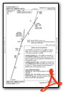
Instrument Approach Procedure (IAP) Charts

Runway Hdg Length       Surface      ILS Name              ILS ID ILS Freq ILS Hdg Open/Closed
25     269 4445 x 107   Dirt                                                       Open
07     89  4445 x 107   Dirt                                                       Open
============
American Creek (80A)
| Elevation: | 503 FT |
| Airport Location: | American Creek, Alaska (N65° 6' 14.33",W151° 10' 38.03") [Google Maps] |
| Airport Information: | [Skyvector] [Airnav] [FlightAware Arrivals] [FlightAware Departures] [FlightPlanDB Arrivals] [FlightPlanDB Departures] |
Runway Hdg Length       Surface      ILS Name              ILS ID ILS Freq ILS Hdg Open/Closed
02     46  1361 x 50    Dirt                                                       Open
20     226 1361 x 50    Dirt                                                       Open
============
Tolovana Hot Springs Airport (83AK)
| Elevation: | 800 FT |
| Airport Location: | Fairbanks, Alaska United States (N65° 15' 23.40",W148° 49' 48.94") [Google Maps] |
| Airport Information: | [Skyvector] [Airnav] [FlightAware Arrivals] [FlightAware Departures] [FlightPlanDB Arrivals] [FlightPlanDB Departures] |
Runway Hdg Length       Surface      ILS Name              ILS ID ILS Freq ILS Hdg Open/Closed
16     180 1503 x 47    Dirt                                                       Open
34     0   1503 x 47    Dirt                                                       Open
============
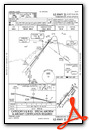
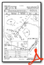
Fairbanks International Airport (PAFA)
| Automated Surface Observing Systems: | 124.400 Mhz |
| Automatic Terminal Information Service: | 124.400 Mhz |
| Elevation: | 432 FT |
| Airport Location: | Fairbanks, Alaska United States (N64° 48' 55.27",W147° 51' 23.97") [Google Maps] |
| Airport Information: | [Skyvector] [Airnav] [FlightAware Arrivals] [FlightAware Departures] [FlightPlanDB Arrivals] [FlightPlanDB Departures] |
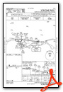
Standard Terminal Arrival (STAR) Charts

Instrument Approach Procedure (IAP) Charts

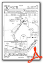


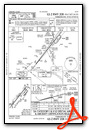


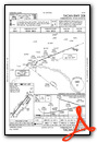
Departure Procedure (DP) Charts


Runway Hdg Length       Surface      ILS Name              ILS ID ILS Freq ILS Hdg Open/Closed
02     38  2872 x 75    Asphalt                                                    Open
20     218 2872 x 75    Asphalt                                                    Open
02R    38  6492 x 92    Asphalt                                                    Open
20L    218 6492 x 92    Asphalt                                                    Open
02L    38  11804 x 145  Asphalt      ILS RW02L             ICNA   109.100  38      Open
20R    218 11804 x 145  Asphalt      ILS RW20R             IFAI   110.300  218     Open
============
Scotts Airport (0AK0)
| Elevation: | 800 FT |
| Airport Location: | Salcha, Alaska United States (N64° 23' 33.01",W146° 51' 43.47") [Google Maps] |
| Airport Information: | [Skyvector] [Airnav] [FlightAware Arrivals] [FlightAware Departures] [FlightPlanDB Arrivals] [FlightPlanDB Departures] |
Runway Hdg Length       Surface      ILS Name              ILS ID ILS Freq ILS Hdg Open/Closed
29     311 1505 x 67    Grass                                                      Open
11     131 1505 x 67    Grass                                                      Open
============
Delta Daves Airport (AA22)
| Elevation: | 1050 FT |
| Airport Location: | Delta Junction, Alaska United States (N64° 7' 58.29",W145° 48' 16.16") [Google Maps] |
| Airport Information: | [Skyvector] [Airnav] [FlightAware Arrivals] [FlightAware Departures] [FlightPlanDB Arrivals] [FlightPlanDB Departures] |
Runway Hdg Length       Surface      ILS Name              ILS ID ILS Freq ILS Hdg Open/Closed
16     180 2348 x 82    Grass                                                      Open
34     360 2348 x 82    Grass                                                      Open
============
Black Rapids Airport (5BK)
| Elevation: | 2125 FT |
| Airport Location: | Black Rapids, Alaska United States (N63° 32' 6.54",W145° 51' 39.19") [Google Maps] |
| Airport Information: | [Skyvector] [Airnav] [FlightAware Arrivals] [FlightAware Departures] [FlightPlanDB Arrivals] [FlightPlanDB Departures] |
Runway Hdg Length       Surface      ILS Name              ILS ID ILS Freq ILS Hdg Open/Closed
33     347 2164 x 65    Grass                                                      Open
15     167 2164 x 65    Grass                                                      Open
============
Mankomen Lake Airport (4AK5)
| Elevation: | 3050 FT |
| Airport Location: | Mankomen Lake, Alaska United States (N62° 59' 23.58",W144° 28' 47.98") [Google Maps] |
| Airport Information: | [Skyvector] [Airnav] [FlightAware Arrivals] [FlightAware Departures] [FlightPlanDB Arrivals] [FlightPlanDB Departures] |
Runway Hdg Length       Surface      ILS Name              ILS ID ILS Freq ILS Hdg Open/Closed
05     71  2116 x 34    Dirt                                                       Open
23     251 2116 x 34    Dirt                                                       Open
============
Deltana Airport (PADB)
| Elevation: | 1941 FT |
| Airport Location: | Deltana, (N62° 36' 34.60",W144° 37' 25.17") [Google Maps] |
| Airport Information: | [Skyvector] [Airnav] [FlightAware Arrivals] [FlightAware Departures] [FlightPlanDB Arrivals] [FlightPlanDB Departures] |
Runway Hdg Length       Surface      ILS Name              ILS ID ILS Freq ILS Hdg Open/Closed
03     49  2094 x 65    Grass                                                      Open
21     229 2094 x 65    Grass                                                      Open
============
Jacobus Field (8AK1)
| Elevation: | 1670 FT |
| Airport Location: | Gulkana, Alaska United States (N62° 16' 49.03",W145° 21' 45.94") [Google Maps] |
| Airport Information: | [Skyvector] [Airnav] [FlightAware Arrivals] [FlightAware Departures] [FlightPlanDB Arrivals] [FlightPlanDB Departures] |
Runway Hdg Length       Surface      ILS Name              ILS ID ILS Freq ILS Hdg Open/Closed
07     92  933 x 71     Grass                                                      Open
25     272 933 x 71     Grass                                                      Open
16     178 968 x 76     Grass                                                      Open
34     358 968 x 76     Grass                                                      Open
============
Copper Center 2 Airport (Z93)
| Elevation: | 1150 FT |
| Airport Location: | Copper Center, Alaska United States (N61° 56' 28.28",W145° 17' 38.70") [Google Maps] |
| Airport Information: | [Skyvector] [Airnav] [FlightAware Arrivals] [FlightAware Departures] [FlightPlanDB Arrivals] [FlightPlanDB Departures] |
Runway Hdg Length       Surface      ILS Name              ILS ID ILS Freq ILS Hdg Open/Closed
14     156 2988 x 82    Asphalt                                                    Open
32     336 2988 x 82    Asphalt                                                    Open
============
Tahneta Pass Airport (HNE)
| Elevation: | 2959 FT |
| Airport Location: | Tahneta Pass Lodge, Alaska United States (N61° 54' 3.27",W147° 18' 32.04") [Google Maps] |
| Airport Information: | [Skyvector] [Airnav] [FlightAware Arrivals] [FlightAware Departures] [FlightPlanDB Arrivals] [FlightPlanDB Departures] |
Runway Hdg Length       Surface      ILS Name              ILS ID ILS Freq ILS Hdg Open/Closed
22     240 1562 x 55    Grass                                                      Open
04     60  1562 x 55    Grass                                                      Open
============
Basquo Airport (52AK)
| Common Traffic Advisory Frequency: | 123.600 Mhz |
| Elevation: | 486 FT |
| Airport Location: | Kenai, Alaska United States (N61° 42' 14.39",W148° 54' 31.67") [Google Maps] |
| Airport Information: | [Skyvector] [Airnav] [FlightAware Arrivals] [FlightAware Departures] [FlightPlanDB Arrivals] [FlightPlanDB Departures] |
Runway Hdg Length       Surface      ILS Name              ILS ID ILS Freq ILS Hdg Open/Closed
19     272 1848 x 49    Grass                                                      Open
01     92  1848 x 49    Grass                                                      Open
============
Wolf Track Airport (9AK8)
| Common Traffic Advisory Frequency: | 122.800 Mhz |
| Elevation: | 350 FT |
| Airport Location: | Wasilla, Alaska United States (N61° 37' 29.07",W149° 40' 55.99") [Google Maps] |
| Airport Information: | [Skyvector] [Airnav] [FlightAware Arrivals] [FlightAware Departures] [FlightPlanDB Arrivals] [FlightPlanDB Departures] |
Runway Hdg Length       Surface      ILS Name              ILS ID ILS Freq ILS Hdg Open/Closed
36     1   1675 x 35    Asphalt                                                    Open
18     181 1675 x 35    Asphalt                                                    Open
============
Secluded Lake Airport (49AK)
| Common Traffic Advisory Frequency: | 122.800 Mhz |
| Elevation: | 300 FT |
| Airport Location: | Talkeetna, Alaska United States (N62° 1' 28.12",W149° 58' 38.04") [Google Maps] |
| Airport Information: | [Skyvector] [Airnav] [FlightAware Arrivals] [FlightAware Departures] [FlightPlanDB Arrivals] [FlightPlanDB Departures] |
Runway Hdg Length       Surface      ILS Name              ILS ID ILS Freq ILS Hdg Open/Closed
25     270 2610 x 28    Dirt                                                       Open
07     90  2610 x 28    Dirt                                                       Open
============
Songlo Vista Airport (3AK3)
| Elevation: | 825 FT |
| Airport Location: | Talkeetna, Alaska United States (N62° 33' 49.56",W150° 13' 13.82") [Google Maps] |
| Airport Information: | [Skyvector] [Airnav] [FlightAware Arrivals] [FlightAware Departures] [FlightPlanDB Arrivals] [FlightPlanDB Departures] |
Runway Hdg Length       Surface      ILS Name              ILS ID ILS Freq ILS Hdg Open/Closed
16     177 1753 x 34    Dirt                                                       Open
34     357 1753 x 34    Dirt                                                       Open
============
Leg 1  > PATA to 80A  > R/wy ?? 02/20 (24nm)    [FlightAware Flights] [FlightAware IFR Analyzer] [FlightPlanDB Routes] [IN SMARTCARS]
Leg 2  > 80A  to 83AK > R/wy ?? 16/34 (60nm)    [FlightAware Flights] [FlightAware IFR Analyzer] [FlightPlanDB Routes] [IN SMARTCARS]
Leg 3  > 83AK to PAFA > R/wy ?? 02L(ILS)/20R(ILS), 02R/20L, 02/20 (36nm)    [FlightAware Flights] [FlightAware IFR Analyzer] [FlightPlanDB Routes] [IN SMARTCARS]
Leg 4  > PAFA to 0AK0 > R/wy ?? 29/11 (36nm)    [FlightAware Flights] [FlightAware IFR Analyzer] [FlightPlanDB Routes] [IN SMARTCARS]
Leg 5  > 0AK0 to AA22 > R/wy ?? 16/34 (32nm)    [FlightAware Flights] [FlightAware IFR Analyzer] [FlightPlanDB Routes] [IN SMARTCARS]
Leg 6  > AA22 to 5BK  > R/wy ?? 33/15 (36nm)    [FlightAware Flights] [FlightAware IFR Analyzer] [FlightPlanDB Routes] [IN SMARTCARS]
Leg 7  > 5BK  to 4AK5 > R/wy ?? 05/23 (50nm)    [FlightAware Flights] [FlightAware IFR Analyzer] [FlightPlanDB Routes] [IN SMARTCARS]
Leg 8  > 4AK5 to PADB > R/wy ?? 03/21 (23nm)    [FlightAware Flights] [FlightAware IFR Analyzer] [FlightPlanDB Routes] [IN SMARTCARS]
Leg 9  > PADB to 8AK1 > R/wy ?? 07/25, 16/34 (28nm)    [FlightAware Flights] [FlightAware IFR Analyzer] [FlightPlanDB Routes] [IN SMARTCARS]
Leg 10 > 8AK1 to Z93  > R/wy ?? 14/32 (20nm)    [FlightAware Flights] [FlightAware IFR Analyzer] [FlightPlanDB Routes] [IN SMARTCARS]
Leg 11 > Z93  to HNE  > R/wy ?? 22/04 (57nm)    [FlightAware Flights] [FlightAware IFR Analyzer] [FlightPlanDB Routes] [IN SMARTCARS]
Leg 12 > HNE  to 52AK > R/wy ?? 19/01 (47nm)    [FlightAware Flights] [FlightAware IFR Analyzer] [FlightPlanDB Routes] [IN SMARTCARS]
Leg 13 > 52AK to 9AK8 > R/wy ?? 36/18 (23nm)    [FlightAware Flights] [FlightAware IFR Analyzer] [FlightPlanDB Routes] [IN SMARTCARS]
Leg 14 > 9AK8 to 49AK > R/wy ?? 25/07 (25nm)    [FlightAware Flights] [FlightAware IFR Analyzer] [FlightPlanDB Routes] [IN SMARTCARS]
Leg 15 > 49AK to 3AK3 > R/wy ?? 16/34 (33nm)    [FlightAware Flights] [FlightAware IFR Analyzer] [FlightPlanDB Routes] [IN SMARTCARS]
